|
|
Home - Tide Plotter - Support - Downloads - Order |

| Tide
Plotter 2007 now available. Download an
evaluation copy now to see
it in action.
Find out exactly what Tide Plotter 2007 can do by visiting our features page. See Tide Plotter 2007 in the screenshot gallery. What Ports are included? Here is a complete list. Read what the press have been saying about Tide Plotter on our reviews page.
|
Tide tables, tide
graphs, tidal streams and a host of tide information, Tide Plotter is the latest
version of the our much loved tidal prediction program for Windows
98/NT4/2000/Me/XP, Windows Mobile Pocket PC and Smart Phone 2003, with UK, Irish, Channel
ports, European from Norway down to Gibraltar and
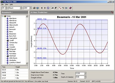
and an East Coast US version. Tide Plotter is easy to use and lets you produce a tidal prediction in just a few easy clicks for any day during the year. New for 2008, a new tidal stream component. This supplements the many extra features added over the years such as a GPS interface, to link the planning map to your GPS and exporting facilities to a spreadsheet comes after the route planner, the outline chart with tide stations, the 'height finder' feature, the tide log and an electronic book entitled 'Working with Tides', this explains the theory of tides with several practical exercises for you to work through. There is also a Logbook and a gallery of high resolution photos and images for personal use. We have added a Pocket PC version and the latest innovation is a version for the mobile phones, Smart Phone. Predictions can be shown in traditional monthly table form, just like in printed tide tables, or as daily graphs. Daily graphs show you every detail of a days tide. Double high and low waters can be seen clearly which is great when using waters such as Poole harbour which have very peculiar tides. In addition to use on your PC, Tide Plotter is ideal used on a laptop onboard a boat, or on a Pocket PC. If you haven't got a laptop to take on your boat then do not fear. Tide Plotter can print both monthly tide tables and daily graphs so you can have the information when away from a computer.
Its not only tides that are calculated. Sunrise and sunset times and moon phases are also shown. Have you ever worried whether you are going to run aground come low water at an anchorage? With Tide Plotter you can bring up today's tidal prediction for your current position, enter the current depth of water and Tide Plotter will calculate whether you are going to run aground at the next low water and if you are it will show on the daily graph the period of time you will be aground for. For a complete list of features in Tide Plotter click here or for a good look at it then visit our screenshot gallery. |